|
Building Face Survey
|
|
Building Face Survey
|
This command enables points on both vertical and nonvertical planes to be coordinated by angle-only observations. This feature is most often used to pick up details of a building where the prism cannot be placed.
The building face is defined by observing three accessible points on the building or by entering their known coordinates. After angle-only observations are made, SurvCE then calculates and stores coordinates of the angle intersection observation with the plane. You can use SurvCE to survey the vertical face of a building or other vertical planes.
Vertical Plane Survey
Select the Building Face Survey option from the Survey menu. When the routine is selected, you are immediately placed in the standard backsight confirmation screen.
If the backsight information is correct, select OK, or press Enter, to move on to the Define Plane dialog box, or otherwise make changes in the backsight screen and re-shoot the backsight. After the instrument is correctly configured, SurvCE will display the Define Plane dialog.
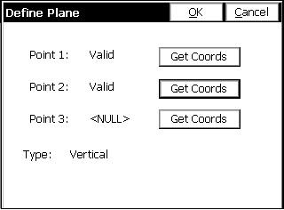

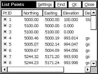
Existing point IDs can be entered into the Point ID field. These points must be defined by coordinate data. As soon as you enter the point ID, press enter and the coordinates will appear in the Northing, Easting, and Elevation fields. Existing points can be selected from a points list by selecting the point list icon. Highlight the desired point and press enter or tap OK.
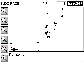
Existing points can be selected from the map screen by selecting the map icon. To select a point, tap it on the screen. If two or more points are close together on the screen, you will be asked to select the intended point from the point list.
Lastly, the points can be “shot” with the total station by pressing Read.
After you have specified the two defining points for the building face plane, SurvCE will determine the available solution. One of the following messages will display in this dialog box.
Press OK, and this dialog will appear.
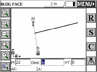
Read (R): The read button takes a reading to the current position of the target. It takes an angle reading only, but assigns a point to that position on the plane (this could be a window or other inaccessible point). The points will appear as “?” symbols on the vertical plane (represented by the dark line) until S for store. They do not plot as points on the screen to avoid clutter. If a reading is taken (R for Read, S for Store or Enter) in a direction that is not on the building face plane, a “No Solution” error message will appear.
Store (S): The store button will store the current position of the target. If the Hgt/Desc Prompt on Save toggle is turned on (See Configure Reading), you will be placed in the Store Point Dialog. SurvCE will store the observed points on the building face using the angle only observations.
Configure (C): This button takes you to the Configure Reading Dialog. Please refer to the Configure Reading section of this manual.
Setup: This button, located at the bottom right of the Map screen, takes you to the Setup dialog for additional instrument setup and benchmarking.
To exit the routine, press the ESC key or the MENU Icon at the top right.
Nonvertical Plane Survey
Surveying a nonvertical plane is similar to surveying a vertical plane. Once the plane has been defined, picking up detailed observations follows the same general process detailed above. All three points must be defined for a nonvertical plane survey. When defining a nonvertical plane, the three points cannot be in a line.