|
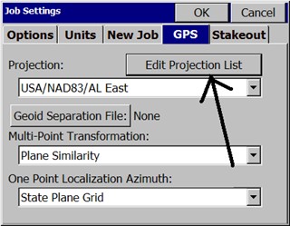
Job Settings (GPS)
|
|
Job Settings (GPS)
|
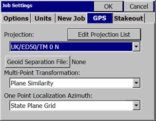
This command allows you to set configuration options for data collection. These options remain set from job to job. Some options may only apply to GPS or to Total Station use. If an option is not applicable, it is grayed out.
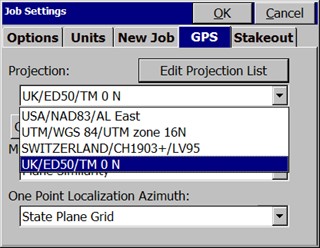
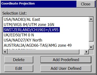
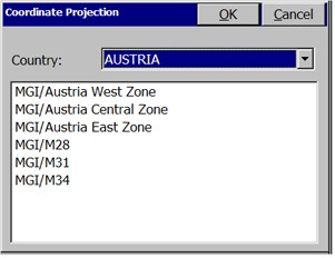
Predefined Coordinate Systems
You may create and select from a list of frequently used or previously selected coordinate systems. Click Edit Projection List to add to the list and to create user-defined projections.
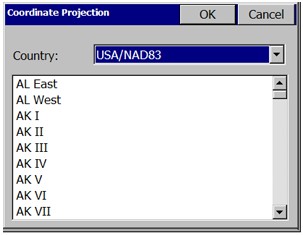
NAD 27: When selecting this coordinate system, you will also need to specify a state plane zone. SurvCE will use data files to perform a NADCON datum shift from WGS84 to NAD27 coordinates. By default, only data files for the continental U.S. are loaded to the data collector. If you are working outside this region, please load the appropriate files from your CD to the SurvStar\NADConv directory. NAD27 uses the Clarke 1866 ellipsoid.
NAD 83: When selecting this coordinate system, you will also need to specify a state plane zone. NAD 83 uses the GRS80 ellipsoid.
UTM: The ellipsoid used in the Universal Transverse Mercator calculation is determined by the Datum selection. If you choose the option, ōWGS 84/Automatic Zone Selectionö, the zone is determined by the lat/lon values read in from the receiver. If you know your UTM zone, you can also select it. Whenever SurvCE does a reverse calculation (from UTM to WGS84) you will be prompted to enter a zone number.
3TM (Canada): This system is also referred to as ōMTMö. It is a 3 degree zone width Transverse Mercator calculation. You may select between the Clarke 1866 ellipsoid and the WGS84 ellipsoid.
New Zealand: You may select between ōNZGD2000ö and ōNZGD49ö. Both use the Transverse Mercator calculation. NZGD2000 uses the GRS80 ellipsoid. NZGD49 uses the International 1924 ellipsoid. You may specify a Meridional Circuit with either datum. To select the circuit, press the ōDefineö button. You will see a pull-down list with all Meridional Circuits as well as the option to pick ōNoneö.
RGF 93 (France): This system requires that you have the file named ōPredef1.cslö in the SurvStar directory on the data collector. If this file is not found, please re-install SurvCE.
NTF (France): This system requires that you have the file named ōPredef1.cslö in the SurvStar directory on the data collector. If this file is not found, please re-install SurvCE. NTF is an approximation of the NTF-GR3DF97A grid transformation.
NTF-GR3DF97A: This system is a grid transformation that requires the files ōPredef1.cslö and ōgr3df97a.binö to be in the SurvStar directory on the data collector. The ōPredef1.cslö file is part of the default installation. You will need to use Data Transfer to copy the ōgr3df97a.binö file from your CD to your data collector.
OSTN02 (UK): This system is a grid transformation that requires the files ōPredef1.cslö, ōostn02_x.binö and ōostn02_y.binö. The ōPredef1.cslö file is part of the default installation. You will need to use Data Transfer to copy the ōostn02_x.binö and ōostn02_y.binö files from your CD to your data collector.
RD2000: This is the RD NAP transformation for the Netherlands. This system is a grid transformation that requires the file ōPredef1.cslö, ōX2C.grdö and ōY2C.grdö. The ōPredef1.cslö file is part of the default installation. You will need to use Data Transfer to copy the ōX2C.grdö and ōY2C.grdö files from your CD to your data collector.
Denmark 34: Used for all cadastral mapping and for most technical mapping carried out in Denmark. System 34 is a two dimensional - horizontal - coordinate system. System 34 is based on the National Geodetic Reference Network and is divided into two different zones, one covering Jutland and Fuen, and the other covering Sealand. The island of Bornholm has its own coordinate system called System 45.
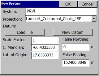
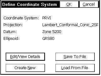
Then click on the "Add User Defined" button. Enter a name for your system (e.g. PRVI for Puerto Rico/Virgin Islands), then select a projection (in the example below, Lambert_Conformal_Conic_2SP) and enter the appropriate parameters. Note that all latitude and longitude values are in decimal degrees and False Northing and False Easting are always presented in meters. All entries involving degree must be in decimal degrees based on a 360 circle.
New Datum: You may select a predefined Ellipsoid or set your own parameters by typing in a new ellipsoid name and entering values for a and 1/f. The values for dX, dY, dZ, rot X, rot Y, rot Z and scale are ōto WGS84ö.
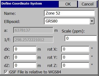
If the values you have are ōfrom WGS84ö, simply reverse the sign of each value (positive becomes negative and vice versa). You will need to save the system to a file. You may save the system to a ōsysö file or a ōcslö file. Sys files contain only one system definition. Csl files contain multiple system definitions. Both files are ASCII text files using OpenGIS WKT (Well Known Text) format.
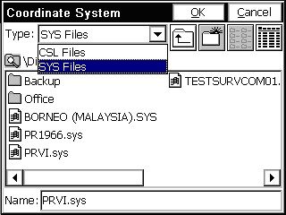
Load File: To load a user defined coordinate system from a file, go to File, Job Settings, GPS and click on the ōEdit Projection Listö. Select ōAdd User Definedö and select Load File. Then click on the ōDefineö button. Select ōLoad Fileö. Change the File Type to ōsysö or ōcslö depending on the type of file you are loading. A ōsysö file will be associated with each job. You can load the projection last used on a survey job by loading its ōsysö file. Select your file and say OK. If you have selected a csl file, you will be asked to choose from a list of system definitions found in the file. For the ōcslö type, you may verify that the details of your system have been loaded correctly by clicking the edit option.
How To Use Geoid Files with Carlson SurvCE
To do this:
Launch ActiveSync and select ōConnection Settingsö from the ōFileö menu.
Remove the checkbox that refers to the port you intend to use with Carlson X-Port (Typically uncheck COM1).
Select OK to exit ōConnection Settingsö and close ActiveSync.