|
Resection
|
|
Resection
|
This command allows you to calculate coordinates of an unknown instrument setup point given the angles and distances from up to twenty distinct reference points. The reference points are recalled from your working job file. Whenever a control file is set active in Job Settings, and the entered point ID is not found in the current working coordinate file, then the point will be recalled from the control file automatically. You can also access points from the control file deliberately by using the ōfrom listö icon.
Direct and Reverse measurements can be activated within the Configure screen in Resection. If you choose ōDirect & Reverseö, then the twenty potential shots (10 F1, 10 F2) equate to ten distinct reference points maximum. As long as you have at least two distinct points, you can shoot the same point twice or more with a direct or D&R measurement. Elevations can be ignored on any measurement. When elevations are used, measurements will contribute to the calculation of the setup point elevation. After entering the routine, the first screen appears as follows:

The points can also be selected from the point list or directly from the map screen by pressing either the list or map icons. You are also prompted for the Instrument Height and a Target Height.
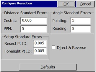
If you press Configure, you can set standard errors for the measurements, as shown below. These settings allow you to take advantage of network least squares and weighting in the calculation performed by SurvCE. The default values are shown. You can also activate Direct & Reverse measurements.
Press Read when you are ready to take a measurement. The angle right, zenith angle and slope distance are recorded.
Repeat this process for all measurements of the resection. After the second measurement, there is enough information to conduct the resection calculation, so the ōCalculateö button at the top of the dialog becomes active and can be selected. This leads to the Store this Point? dialog.
In the ōStore this Point?ö dialog box shown below, you are prompted for the point number and description of the calculated point (the occupied station/setup point). With three or more resection points, residuals are presented showing the accuracy of the calculation.

After the resection is calculated by least squares, the results of the resection are displayed. The input data is displayed in a list structure and the user has the option to turn certain measurements on/off and recalculate the solution, without the necessity of re-measurement. You can edit point numbers, instrument and rod heights, etc. When satisfied with your edits and the solution, you can store the results of the resection.
Since there is redundant data, the final calculated coordinate differs slightly from the individual measurements. The command reports the calculated coordinate’s northing, easting, and elevation and the difference between the calculated coordinate and the individual solutions as the residuals, which indicate the quality of the data. High residuals suggest a problem with the input data. When you press OK from the Store this Point? screen, you will be setup on the calculated point backsighting the first point shot in the resection.