|
Configure Base/Rover (Sokkia GPS)
|
|
Configure Base/Rover (Sokkia GPS)
|
Sokkia Radian
This is the driver for the original Sokkia Radian ōreal-timeö GPS with centimeter accuracy. Sokkia Radian GPS, like all real-time, high-accuracy GPS requires a base receiver sending corrections to a rover receiver. Most commonly used GPS antenna types include the SK600 and SK502. All Sokkia GPS receivers will accept and transmit RTCM, RTCA and CMR message strings.
Sokkia Radian IS
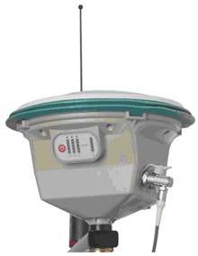
The Radian IS is an ōintegratedö GPS receiver with a fixed antenna type, the SK600. Antenna height on the integrated Radian IS with built-in SK600 antenna is measured to the base of the rubber bumper around the antenna. Sokkia provides a measuring tape that connects to the rectangular indentations for precise height measurement. A diagram of the phase center offset (antenna height) is included on the receiver. Similar ōhook pointsö exist on all Sokkia antennas.
Sokkia GSR2600 GPS
The GSR2600 is a modular version of the Radian IS, with a variety of antenna types available. The Log Static Data routine in SurvCE will initialize the storing of raw data to the receiver. This raw data can be post-processed in Sokkia Spectrum Survey.
Sokkia Axis/Axis 3 GPS
The Sokkia Axis 3 is the current GIS-level GPS product from Sokkia and obtains corrections from Coast Guard beacons, WAAS and OmniStar. There is no subscription fee for beacons or WAAS, but there is for OmniStar. The subscription can be by month or year or any other time period (even ōweekendö use). Accuracy varies on correction method used, but is typically sub-meter to 3 meters. For example, 0.5 meter accuracy (1.5 feet) is common with beacon corrections when located within 60 miles of a Coast Guard beacon. The Axis 3 is designed for GIS and environmental applications, which are effectively addressed by SurvCE through use of attributing on feature codes and through ESRI import and export features.