|
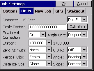
Job Settings (Units)
|
|
Job Settings (Units)
|
This command allows you to set configuration options for data collection. These options remain set from job to job. Some options may only apply to GPS or to Total Station use. If an option is not applicable, it is grayed out. This figure shows the options available when the Units tab is selected.
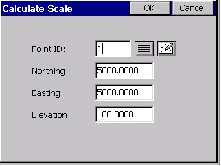
To match the coordinates of any standard transformation (e.g. UTM, NAD83), the scale factor should be set to 1.0. When configured to total stations, the Calculate option will calculate the combined grid/elevation factor from any entered coordinate—based on your current state plane zone setting. This can allow you to go “ground to grid,” to typically reduce the distance measured by total station to the sea level grid distance of GPS. If set to a GPS configuration, Calculate becomes Read GPS. The Read GPS option is ghosted if a multi-point localization is active. In that case, the scale factor is fixed by the localization itself, and is the inverse of the value appearing in localization, because within Units, we display the “ground to grid” number, whereas in localization, we display the “grid to ground” multiplier. But for base or 1-point rover localizations, Read GPS applies. After converting the LAT/LONG from the GPS to the state plane coordinates and computing the grid and elevation factors, the Scale Factor is applied as the final adjustment to the coordinates. This adjustment is used on the X,Y and not the Z. In GPS, the Scale Factor is applied by dividing the distance between the coordinate and a base point by the Scale Factor. The coordinate is then set by starting from the base point and moving in the direction to the coordinate for the adjusted distance.
The base point is the first point appearing in the GPS Localization option. If there are no points specified in Localization, then 0,0 is used as base point. The Scale Factor can be entered directly or calculated using the grid factor and elevation for the current position. When using the current position, the program will read the LAT/LONG from the GPS receiver. The scale factor is then calculated as: (State Plane Grid Factor - (Elevation/Earth Radius)). A scale factor can be used to make grid-to-ground conversions between identical points, to adjust the lesser sea level distances of GPS to the ground (greater) distances measured by total stations whenever you are above sea level. The grid to ground scale factor is lower at higher elevations because it acts as a divisor (the scale factor is always defined as “ground to grid”). In summary, when configured to GPS, the scale factor (typically <1) can be used to go “grid to ground” through division and when configured to total stations, the scale factor (typically <1) can be used to go “ground to grid” through multiplication. It can also be used for any other scaling purpose desired, but be advised that any scale factor used for GPS is used as a divisor. Because there are two potential uses of the scale factor (to adjust GPS measurements and to adjust total station measurements), two distinct scale factors are stored and recalled for any job, one for when you are configured to a GPS instrument and one for when you are configured to total stations.
Choosing Calculate will give you this dialog.