Default values in Comm Setup are 9600, Parity None, Char Length 8, Stop Bits 1. These can be set by hitting ōDefaultsö. For the GX1200 series GPS, the default baud rate is 115200.
Configure Base
This command opens the Base Configuration dialog.
- Sensor Type: This option determines the model of the GPS (e.g. 500 or 1200).
- Base Antenna: This option allows the user to specify the antenna in use. The most common setting for the base antenna is AT502 Tripod type.
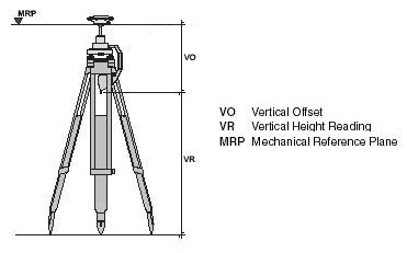
- Antenna Height: Input the base antenna height. The AT501 Tripod, AT502 Tripod, AT503 Tripod and AT504 Tripod settings will all prompt to ōMeasure to Base of 36cm Height Hookö.
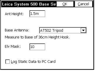
When the height hook is used, the Antenna Height is measured down to the hub and tack elevation from the fixed mounting position of the height hook. The measurement is typically in meters, so if you are configured to units in feet, you can enter the Antenna Height in meters with the ōmö suffix, as shown above, and the program will do the conversion automatically. You can omit the ōmö suffix if you are configured to metric units.
Other Antenna settings for Leica GPS are AT201, AT202/302, AT202/302GP, AT303, AT501, AT501 Pole, AT502, AT502 Pole, AT503, AT504, SR299/399 Internal, AX1201, AX201 Pole, AX1201 Tripod, AX1202, AX1202 Pillar, AX1202 Pole, AX1202 Tripod and ōOtherö. In all these cases, the antenna height is measured from the ground elevation to the base of the antenna (the ōbaseö is where it would rest if you removed it and placed it on a table—the ōbaseö is the lowest point).
- Elv Mask: This specifies the cutoff vertical angle above the horizon. Any satellites below this angle will be left out of calculations. An elevation mask of 10 degrees is typical. It is advisable to use some elevation mask between 5 and 15 degrees. Satellites low to the horizon can actually degrade the resolving of the GPS position.
- Log Static Data to PC Card: This option will log static data in binary form to the PC Card in the GPS receiver whether or not you choose to conduct RTK GPS work. The static data can be processed using the Leica SKI-Pro program.
Configure Rover
This command is used primarily to set the appropriate antenna height and antenna type for the rover. Leica typically offers a 2-meter pole, so for antenna height, the most common entry is 2m or 6.5617 feet. The default antenna is the AT502 Pole.
- Sensor Type: This option determines the model of the GPS (e.g. 500 or 1200).
- Rover Antenna: This option allows the user to specify the antenna in use. The most common setting for the base antenna is AT502 Tripod type.
- Antenna Height: Input the rover antenna height. The AT501 Tripod, AT502 Tripod, AT503 Tripod and AT504 Tripod settings will all prompt to ōMeasure to Base of 36cm Height Hookö. When the height hook is used, the Antenna Height is measured down to the hub and tack elevation from the fixed mounting position of the height hook. The measurement is typically in meters, so if you are configured to units in feet, you can enter the Antenna Height in meters with the ōmö suffix, as shown above, and the program will do the conversion automatically. You can omit the ōmö suffix if you are configured to metric units. Other Antenna settings for Leica GPS are AT201, AT202/302, AT202/302GP, AT303, AT501, AT501 Pole, AT502, AT502 Pole, AT503, AT504, SR299/399 Internal, AX1201, AX201 Pole, AX1201 Tripod, AX1202, AX1202 Pillar, AX1202 Pole, AX1202 Tripod and ōOtherö. In all these cases, the antenna height is measured from the ground elevation to the base of the antenna (the ōbaseö is where it would rest if you removed it and placed it on a table—the ōbaseö is the lowest point).
- Elv Mask: This specifies the cutoff vertical angle above the horizon. Any satellites below this angle will be left out of calculations. An elevation mask of 10 degrees is typical. It is advisable to use some elevation mask between 5 and 15 degrees. Satellites low to the horizon can actually degrade the resolving of the GPS position.
- Log Baseline Data: This option stores raw vector data and Cartesian coordinate data for both the base and the rover and stores to the SurvCE data collector, in the ōDataö directory. The file will be Jobname_SKI.ASC, depending on the name of the coordinate file. This vector file can be further processed in the Leica SKI-Pro program.