|
Station Store
|
|
Station Store
|
Station Store is a pure calculation routine that will create points based on a station and offset from an alignment. The alignment may be defined as a centerline, a 3-point arc, an arc defined by a PC, Radius and PT, a selected polyline or a sequence of points. The user may also assign an elevation to the calculated point. Station Store might be used to enter elevations of pipe culverts, for example, where inlets and outlets are located at distinct stations, offsets and elevations. Then the two calculated points at the inlet and outlet can be used within Stakeout Line to stake any point along the culvert, with the cut/fill calculated. Although the command Stake Centerline, found within Stakeout Line/Arc, will directly stakeout a particular station and offset to a centerline, some users prefer to pre-calculate the station and offset and assign a point ID, then stake by point ID. Station Store permits this pre-calculation of points at any station and offset.
The very first screen within Station Store offers several methods of defining an alignment.
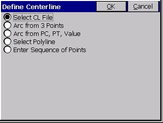
The routine defaults to the most automatic of the methods—use of a pre-defined centerline file. To review, centerline files can be made by use of the command Input-Edit Centerline File (item 1 within the Road menu). Alternately, centerlines can be uploaded to the SurvCE program from a PC in forms including LandXML, SDR, TDS, ASCII LDD, TM (Terramodel) and Carlson/AutoDesk Field Survey. Unless the file format is Carlson/Autodesk Field Survey, the command Centerline Conversion within Road Utilities should be used to convert the ōforeignö centerline format to the ō.clö form used by SurvCE.
You can follow along by loading the file demo.cl within the command Station Store. Then, on the data entry screen, enter a station of 101.25, offset of -35.5, and elevation of 996.04, as shown below (any unused point ID will do).
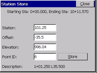
Pressing Enter will move through the dialog and store the point, leaving the screen up for more entries, while defaulting to the previous data and the next point ID. The description is fixed as the station and offset, but could be edited using the command Keyboard Input. You could continue by entering a right-side station and offset, such as station 117.25, offset 29.71, elevation 1003.67 for point number 7. Then the 2 calculated points might define a ōskewedö pipe culvert, ready for stakeout using the command Stakeout Line/Arc. You could also choose to stakeout the endpoints of the culvert by point ID using the command Stakeout Points.
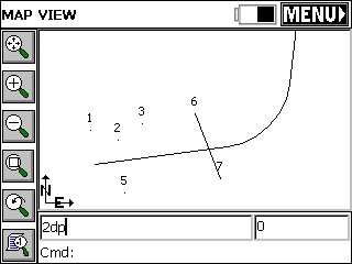
You can draw the demo.cl by doing the command CL2P at the ōcommandö line in the MAP view. It is also found under the ōToolsö pulldown in the MAP view.
The line representing the culvert is drawn by the command 2DP, which stands for ō2D polylineö.